Previous photo Next photo Thumbnail page
edgartownlight gayheadlight gayheadcliffs gh-cliffs-light dt-rt-overlook dt-rt-mnmshw-wide dt-rt-mnmshw-cu rt-kayak-mnmshw rt-mt-porch rt-wading
First page Previous page Index page Next page Last page
gh-cliffs-light  [4 of 18]


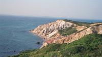
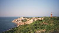
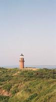
Gay Head cliffs and light, from the overlook. To the right is the entrance of Buzzards Bay. About 45 degrees to the left is Cuttyhunk, last and smallest inhabited island of the Elizabeth Islands chain. JFK Jr's plane went down about 4.5 miles to the left (west). To the east (right) lie Lobsterville and across the inlet, the fishing village of Menemsha.
Click to show/hide keyboard shortcut help
Keyboard shortcuts are active:

RIGHT arrow - next page
LEFT arrow - previous page
Page Up - index page
HOME - first page
END - last page
ESC,S,s - toggle start/stop slide show
ExhibitPlus gh-cliffs-light Gay Head cliffs and light, from the overlook. To the right is the entrance of Buzzards Bay. About 45 degrees to the left is Cuttyhunk, last and smallest inhabited island of the Elizabeth Islands chain. JFK Jr's plane went down about 4.5 miles to the left (west). To the east (right) lie Lobsterville and across the inlet, the fishing village of Menemsha.

edgartownlight gayheadlight gayheadcliffs gh-cliffs-light dt-rt-overlook dt-rt-mnmshw-wide dt-rt-mnmshw-cu rt-kayak-mnmshw rt-mt-porch rt-wading
First page Previous page Index page Next page Last page